A comprehensive map of Victoria for touring throughout the state that has camping and rest areas, 24-hour fuel and points of interest marked on the mapping. On the reverse are CBD, the surrounding region and through road maps of Melbourne in addition to maps of the Great Ocean Road and East Gippsland. Also included is…
These light but strong polymer waterproof bags from Lifeventure will protect anything you care to put in them from water damage, scratching, religious conversion etc. The press-seal LocTop is rated to IPX8, that submersible up to 10m for 30 minutes. The large pack is designed for maps but comes with three different sized bags that…
John Chapman and his co-authors spend their lives hiking all over this great land and writing guide books so the rest of us can follow them. Through years of refinement John & Co’s books are well laid-out and colourfully illustrated that detail routes, background, safety, trip planning and further reading.
Guidebook to the Pennine Way National Trail with OS map booklet. The 265 mile route from Edale to Kirk Yetholm takes three weeks to walk and is suitable for fit and experienced long distance walkers. The route crosses the Peak District, Yorkshire Dales and North Pennines National Parks. Includes separate OS 1:25,000 map booklet of…
Had plans to do the Camino this year Maybe your Everest Base Camp trek was cancelled Don’t worry! The Great North Walk is just what you’re looking for! The 250km walk between Newcastle and Sydney is stunning, challenging and right in your backyard. This new section-by-section guide includes full-colour photography, accurate maps, and info on…
These maps highlight the walking tracks and features tourist information along with general topographic detail and is essential for walkers. The notes on the reverse side introduce visitors to the vegetation, land forms, animals, history of the area, bushwalking tips, safety essentials and booking requirements. Scale: 1:100,000.
The Grampians region is one of the most popular destinations in Victoria for bushwalking and outdoor recreation. This detailed topographic map contains the latest road and walking trail networks, including the first stage of the new Grampians Peaks Trail, and locations of all the recreation sites in the region. A detailed (1:25,000) map of Halls…
The excellent Cicerone guidebook to walking the Camino dos Faros, the way of the lighthouses on Spain’s Galician coast. The 200km route is described across eight stages and takes in some of the area’s most enchanting coastal scenery. Incorporates some challenging walking.
These are the official 1:25 000 scale topographical maps from the NSW government Land & Property Division, covering the most outstanding areas of the state on a well-produced, reversible, fold-out map perfect for hikers.
Cicerone guide details the Camino del Norte and Camino Primitivo pilgrim routes. The Camino del Norte covers 820 kms and takes you from Irún via Bilbao and Santander takes around 5 weeks to complete. The 355km Camino Primitivo takes about 2 weeks. The book also includes the Camino Finisterre from Santiago to the coast.
Cicerone’s essential guidebook for walking the GR5 trail, 660km from Lac Leman (Lake Geneva) to Nice or Menton, through the French Alps. Includes all the main variant routes as it passes Mont Blanc, then through the Vanoise, the Queyras and the Mercantour National Parks. Includes accommodation, profiles and maps. Suitable for fairly experienced hikers.
Cicerone’s excellent guidebook to 22 multi-day treks in the Himalayan Kingdom of Bhutan, including the Jhomolhari, Druk Path and Dagala treks. The trails vary from 2 to 23 days long. The routes are mostly in western and central Bhutan, and range from easy to strenuous depending on the length, altitude and difficulty. Includes advice on cultural…















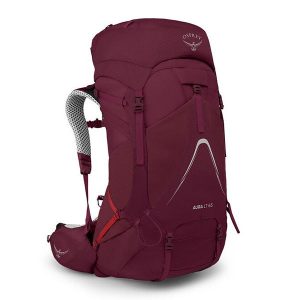 Aura AG LT 65
  Cairns to Broome Map