Hema’s map of the Northern Territory that has camping and rest areas, 24hour fuel and points of interest. On the reverse are through road maps of Darwin and Alice Springs, and a map of the greater Darwin region. For trip planning, there is a national park matrix and contact details for information centres.
These maps highlight the walking tracks and features tourist information along with general topographic detail and is essential for walkers. The notes on the reverse side introduce visitors to the vegetation, land forms, animals, history of the area, bushwalking tips, safety essentials and booking requirements. Scale: 1:100,000.
John Chapman and his co-authors spend their lives hiking all over this great land and writing guide books so the rest of us can follow them. Through years of refinement John & Co’s books are well laid-out and colourfully illustrated that detail routes, background, safety, trip planning and further reading.
John Chapman and his co-authors spend their lives hiking all over this great land and writing guide books so the rest of us can follow them. Through years of refinement John & Co’s books are well laid-out and colourfully illustrated that detail routes, background, safety, trip planning and further reading.
Cicerone guide details the Camino del Norte and Camino Primitivo pilgrim routes. The Camino del Norte covers 820 kms and takes you from Irún via Bilbao and Santander takes around 5 weeks to complete. The 355km Camino Primitivo takes about 2 weeks. The book also includes the Camino Finisterre from Santiago to the coast.
These Tasmanian maps are recommended for regional planners and visitors intending to travel a little off the beaten track. The map is popular with drivers, cyclists and people wanting a regional overview of an area. The maps are available in folded and flat form and may be joined together to create an impressive wall map.
Cicerone’s essential guidebook for walking the GR5 trail, 660km from Lac Leman (Lake Geneva) to Nice or Menton, through the French Alps. Includes all the main variant routes as it passes Mont Blanc, then through the Vanoise, the Queyras and the Mercantour National Parks. Includes accommodation, profiles and maps. Suitable for fairly experienced hikers.
The Cairns to Broome map has all the the info you need for planning this epic road trip. From national parks maps, to fuel locations, caravan parks, info centres and adventure ideas it has it all. It comes with comprehensive info on amazing attractions along the way, this is THE map to plan a Cairns to Broome…
John Chapman and his co-authors spend their lives hiking all over this great land and writing guide books so the rest of us can follow them. Through years of refinement John & Co’s books are well laid-out and colourfully illustrated that detail routes, background, safety, trip planning and further reading.
John Brierly is one of the acknowledged experts in walking the pilgrim’s route of the Camino Frances, Way of St. James, or Camino de Santiago, in northern Spain. For walkers who do not wish to carry the full guide book, and who only require maps, John has produced this map kit, with full daily stage…
















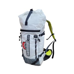 Solitary 35L Ultralight
  Trekking the GR10 Trail