All the mapping you need to complete the 95 mile (153km) West Highland Way, an official Scottish Long Distance Route from Milngavie near Glasgow to Fort William. Showcasing the wild beauty of western Scotland, the trail is a journey from the lowlands to the highlands, passing Loch Lomond then crossing Rannoch Moor before finishing in…
These maps highlight the walking tracks and features tourist information along with general topographic detail and is essential for walkers. The notes on the reverse side introduce visitors to the vegetation, land forms, animals, history of the area, bushwalking tips, safety essentials and booking requirements. Scale: 1:100,000.
Cicerone’s guidebook to the Via Podiensis (Chemin du Puy) pilgrim route along the GR65 through southern France to the Pyrenees. The 750km route links Le Puy-en-Velay with Saint-Jean-Pied-de-Port and the start of the Camino Frances to Santiago. Includes Cele Valley and Rocamadour variants.
It’s no good having a map if it’s all soggy – contour lines tend to blur, transforming gentle slopes into towering cliffs. Avoid such topographical catastrophes by protecting your map in this practical map case. The welded design will protect paper from water and dust, and the TPU (thermoplastic polyurethane) is UV resistant and folds…
This is one of a series of excellent guide books from the Cicerone. Their guides are an inexpensive option for hikers heading all over the world looking to explore the world’s best walks and treks, mountains and cycle routes. This book details Nepal’s Annapurna region covering 14 treks including the Annapurna Circuit and Sanctuary treks.
A thoroughly revised fourth edition of the bestselling Blue Mountains Best Bushwalks is the perfect companion for the bushwalking fan. The book features: 67 different walks, varying in length from 30 minutes to two days, accurate, full colour maps and step by step directions, detailed walk statistics including distance, total ascent/descent, grade and estimated time,…
John Chapman and his co-authors spend their lives hiking all over this great land and writing guide books so the rest of us can follow them. Through years of refinement John & Co’s books are well laid-out and colourfully illustrated that detail routes, background, safety, trip planning and further reading.
This touring map traverses Australia from Melbourne to Adelaide (1:900,000) and features an inset map of the Great Ocean Road (1:450,000). The latter map pinpoints significant locations along the route with tourist information attached and is accompanied by other useful information to illuminate the journey. Through-road maps of Melbourne to Adelaide are also included.
John Brierly is one of the acknowledged experts in walking the pilgrim’s route of the Camino Frances, Way of St. James, or Camino de Santiago, in northern Spain. For walkers who do not wish to carry the full guide book, and who only require maps, John has produced this map kit, with full daily stage…
Journey along dramatic escarpments, across gorgeous rivers and through remote bushland on one of Australia’s historic long-distance walks: The Six Foot Track. This full-colour guide outlines all the info you’ll need to tackle this 44km Blue Mountains classic, including maps, estimated times, details on historic points-of-interest, possible accommodation along the hike and even public transport…
The excellent Cicerone guidebook to walking the Camino dos Faros, the way of the lighthouses on Spain’s Galician coast. The 200km route is described across eight stages and takes in some of the area’s most enchanting coastal scenery. Incorporates some challenging walking.
The Expedition now has a sighting mirror! Silva’s Expedition S retains the rugged Dryflex housing, magnetic declination adjustment screw and numerous scale markers of it’s progenitor, but now includes a crystal clear mirror hidden in a defensive case. A must have for the intrepid bush-basher. All Silva compasses include a pamphlet explaining their 1-2-3 map-reading system…


















 Camp Cutlery Spork
  Side Release Buckle 2 Pin
 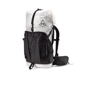 Southwest 55L
  Jervis Bay Five Fantastic Walks of Discovery
  Great North Walk Map Kit
  NSW Topo Map 1-50 000 COONABARABRAN 8735S