Cicerone’s excellent guidebook to 22 multi-day treks in the Himalayan Kingdom of Bhutan, including the Jhomolhari, Druk Path and Dagala treks. The trails vary from 2 to 23 days long. The routes are mostly in western and central Bhutan, and range from easy to strenuous depending on the length, altitude and difficulty. Includes advice on cultural…
Silva’s Expedition is the front-runner in their series of world-leading compasses.The base plate model has four different map-measuring scales for ultimate versatility, a screw for built-in declination adjustment and a rugged Dryflex housing. This is the perfect mid-range compass for heavy expeditions. All Silva compasses include a pamphlet explaining their 1-2-3 map-reading system which demystifies…
Cicerone guide details the Camino del Norte and Camino Primitivo pilgrim routes. The Camino del Norte covers 820 kms and takes you from Irún via Bilbao and Santander takes around 5 weeks to complete. The 355km Camino Primitivo takes about 2 weeks. The book also includes the Camino Finisterre from Santiago to the coast.
These light but strong polymer waterproof bags from Lifeventure will protect anything you care to put in them from water damage, scratching, religious conversion etc. The press-seal LocTop is rated to IPX8, that submersible up to 10m for 30 minutes. The large pack is designed for maps but comes with three different sized bags that…
Guidebook to the GR10, a 955km trek across the French Pyrenees from Hendaye on the Atlantic Coast to the Mediterranean coast at Banyuls-sur-Mer. Described in 55-day stages of 7-27km, the route can be completed in its entirety, usually in around 45 days, or in shorter sections using the bus and rail links found throughout the…
The Exped Seal Sleeve is a range of simple and compact cases that are fully 100% Waterproof and touchscreen compatible. If your next adventure might require you to keep your phone, tablet, wallet, map, money or documents from ending up in the drink – This is the product. Exped has developed a super strong zip…
These are the official 1:25 000 scale topographical maps from the NSW government Land & Property Division, covering the most outstanding areas of the state on a well-produced, reversible, fold-out map perfect for hikers.
Hema’s map of the Northern Territory that has camping and rest areas, 24hour fuel and points of interest. On the reverse are through road maps of Darwin and Alice Springs, and a map of the greater Darwin region. For trip planning, there is a national park matrix and contact details for information centres.
This Cicerone guidebook describes 110 gill and crag scrambling routes in the south of the Lake District, with sections covering Wasdale, Ennerdale and Buttermere, Borrowdale, Thirlmere, Patterdale, Mardale and Swindale. The guidebook includes invaluable of advice on equipment, safety, rope techniques, and scrambling techniques, as well as notes on access and conservation. The Lake District’s…
This Cicerone guidebook gives stage-by-stage directions for the Central Camino, starting from Lisbon, Porto or Tui, the Coastal Camino between Porto or Vigo, and the Spiritual Variant route from Pontevedra to Redondela. It also describes link routes that can be used to swap from one route to another. Detailed route guidance and maps are accompanied…
All the mapping you need to complete the 95 mile (153km) West Highland Way, an official Scottish Long Distance Route from Milngavie near Glasgow to Fort William. Showcasing the wild beauty of western Scotland, the trail is a journey from the lowlands to the highlands, passing Loch Lomond then crossing Rannoch Moor before finishing in…
These are the official 1:25 000 scale topographical maps from the NSW government Land & Property Division, covering the most outstanding areas of the state on a well-produced, reversible, fold-out map perfect for hikers.
















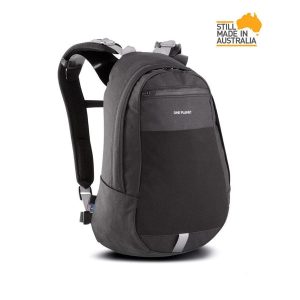 Boonah 20L Canvas Day Pack
  Bushwalking in Australia